The dog days have begun to initiate some climbing fun without the crowd.
How Long is the Climb/Trek?
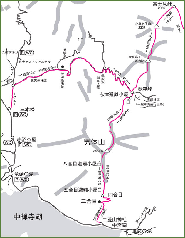
My fiance and I decided to climb Mt. Nantai located in the Nikko area of Tochigi prefecture. We took the road less traveled, a 14 mile course that starts from the official entrance of the mountain (Chuzenjiko Temple) and ends at the Senjogahara moor/ swamp. We took this route because the standard route was too easy. The Standard Route consisted of going to the top and going back the same way down. Our route was different and added a dozen miles trekking through the north face to descend the mountain.
For those without the experience and the will for challenge, I recommend to not use the route we took.
Elevation?
The elevation at the summit of Mt. Nantai is 8,156 feet above sea level, I will note that the climb presented towards the top was a bit steep. Near the summit of Mt. Nantai, the setting becomes reddish and the mountain rocks (volcanic rocks) are similar to those found on Mt. Fuji.

Also there have been reports of some climbers suffering from altitude sickness at this altitude so if you suffer easily from hypoxia, you should rest accordingly when needed.
Through my personal account, I didn’t even notice the air thinning but I was really hungry when I reached the top.
A Rare Route Taken
The route we took is not very common among average climbers because of the long distance and the existing snow that continued to lay on the north face of Mt. Nantai. In addition to that, descending down Mt. Nantai through the Shizu route is quite dangerous because of the slippery icy paths.
I should also mention that my fiance and I were the only individuals descending through the Shizu path that day. It was pretty lonely and dangerous. But isn’t that why we climb; its for the solitary and the adventure.
I surveyed the path and noted the snow was not fresh and melting. These conditions are bad for slips during descents but ideal as avalanches are rare in these conditions. We used crampons as we descended and our descent was non-eventful.

The Best and the Worst?
One of the best parts of our climb besides being away from the office was the ability to see Mt. Fuji and other mountain ranges as we ascended to the summit. The worst part of the climb was descending through a maze of trees and melting snow. Most of the trail markers were still covered in snow so a compass and good tracking ability was necessary. Finally, avalanche risks were present but well prepared for.
Please note that this mountain or any other mountain should not be underestimated as a simple easy trek/ climb. A climber went missing 5 days before our climb and is still yet to be found. As we descended down the Shizu path, we noticed a rescue chopper flying overheard making slow passes several times while the base of the mountain consisted of a pack of volunteers escorted by J-cops searching for the lost man.

For more of my pictures of my climb, check out GoStudios.jp, which is my official studio website. (Beware it’s in Japanese)
If you have any questions, feel free to comment below!
Here’s a blog on the kind of gear I bring when climbing!
For more info about Nt. Nantai: http://en.wikipedia.org/wiki/Mount_Nantai
How long was the climb?
How long did it take to finish your climb?
Time to finish
The whole course of 14 miles took about 10 hours to finish.